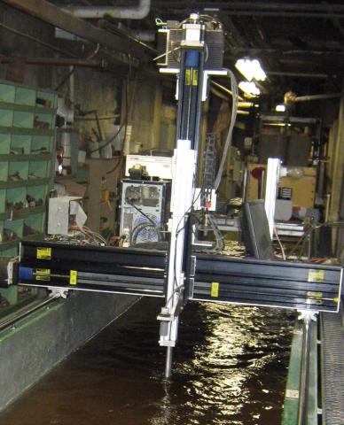
Here, I describe a method for obtaining repeat transects of bed elevation using a sonar, water surface scanner, and automated cart setup (see associated Equipment entry) on the Tilting Bed Flume (see assocated Set-up entry) at the Saint Anthony Falls Laboratory (see associated Facility entry).
Topography is measured with a JSR Ultrasonic DPR 300 Pulser / Receiver. The sonar arm moves up and down the length of the flume on a cart sliding on rails on the walls of the flume. The sonar is attached to a vertical arm extending downward from the cart, and its sensor is minimally submerged about 1 cm below the water surface (to reduce flow disturbances). To maintain constant submergence of the sonar, a MassaSonic M-5000/220 ultrasonic probe is also attached to the cart to determine water surface height. Resolution on position of the sonar arm is about 1 cm in the horizontal direction and 0.25 mm in the vertical direction. The sonar takes about 10 seconds to make an 8 meter longitudinal traverse of the flume (the sonar could move faster, but this would compromise the quality of the collected data).
The sonar receiver obtains waveforms generated from reflection of the sonar pulse off the bed surface. This waveform is converted to a bed elevation based on an algorithm in the automated cart system. The resolution of the estimated bed elevation is <1 mm, but estimated elevation accuracy is 1 mm due to uncertainty in picking out the sonar waveform. Bed elevation estimates obtained from the sonar do not seem to be affected by water clarity, though areas of significant sediment suspension do seem to increase the number of errors in estimates of bed elevation.