This collection contains the photographs and the topographic scans of the experiments published in Bufe A., Paola C., Burbank D.W., 2016. Fluvial bevelling of topography controlled by lateral channel mobility and uplift rate. Nature Geoscience., 9(9), 706-710, doi:10.1038/ngeo2773.
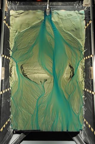
For each experiment photographs were taken at regular intervals with a 10.5-mm, f/2.8 fisheye lens mounted on a DSLR camera. Fisheye distortion was removed using the inbuilt lens correction in Photoshop CS6 and were tilted such that the average slope of the alluvial fan is horizontal. Photos taken while the water was not running or when the dye feed was interrupted were not used. Moreover, for Run 4 only photographs from the first 25 h of runtime were processed and uploaded to the repository. All raw unprocessed images can be obtained upon request.
Topographic data of the basin were acquired using a custom built laser scanner that was programmed to cover the entire basin except for its upper ~5% (~25 cm), in six swaths. The scans are provided as .dat file and have 4672 by 3001 mm2 sized pixels.
To open the datafile in MATLAB :
id=fopen(‘filename’,'r')
A=fread(id,[4672 3001],'float');
fclose(id);
The Metadata for the experiments is summarized in an excel spreadsheet. For each run there are entries about the input parameters as well as the timing of uplift events and the timing of topographic scans.